Mapping Matatus: Geolocation Data and Public Transit in Nairobi
DATA
Using geolocation technologies in smartphones, researchers mapped networks of informal buses, called matatus, in Nairobi, Kenya
IMPACT
Digital Matatus has provided tools to help Nairobi improve matatu routing and reduce traffic congestion
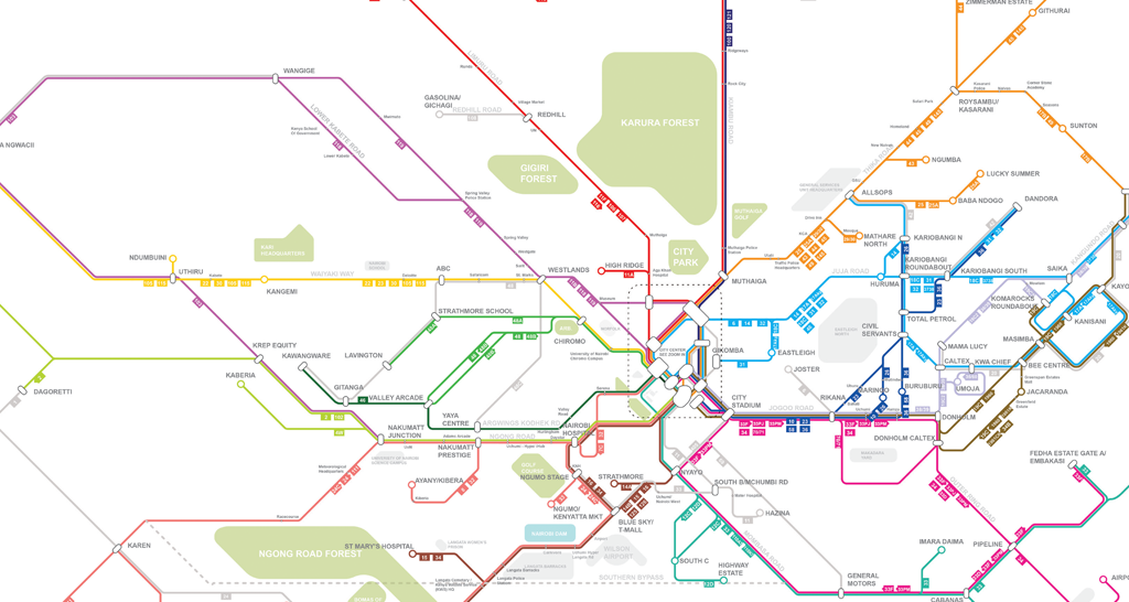
Source: Obtained from Digital Matatus project. Used with permission.
Private buses known as matatus are the primary mode of motorized transport in Nairobi, with about 3.5 million regular riders.1 In a collaborative effort called Digital Matatus, researchers from Columbia University, the Massachusetts Institute of Technology, and the University of Nairobi used GPS tracking devices and smartphone data to create a digital map of Nairobi’s matatu routes, pictured above. University of Nairobi students geolocated stops along routes and recorded important information such as which stops are formally recognized by the city. This map and database is available for riders, government officials, and programmers seeking to create other transit applications.2
Local Civic Change
The Digital Matatus project helped passengers discover more efficient routes of commuting. The new dataset will also help regulate bus stop locations; the project found that many buses stop erratically along the road to pick up passengers, with detrimental effects on traffic. The data collected by this project is also the first official record of existing routes. This information facilitates civic engagement and feedback during the transit planning process to incorporate some of the matatu routes into formal bus routes offered by the city.3
Open Data for Tech Entrepreneurship
By making the data openly available through Global Transit Feed Specification (GTFS) format, Kenyan tech start-ups have developed useful mobile applications for Nairobi’s citizens. Apps that suggest optimal routes, provide warnings about unsafe areas near matatu stops, and allow users to hail matatus by requesting pick-up at a specific location are now available.4
Global Ripples
The dissemination of these results sparked government planners in Nepal, Nigeria, Ghana, and other countries to approach the research team about adopting similar methods for their own public transportation systems.5 With the informal transport sector playing such an important role in cities of the developing world, innovations like Digital Matatus are critical for municipal efforts to improve transit efficiency.
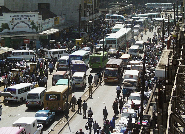
Photo: Rogiro, “Nairobi Traffic Jam,” Nairobi, Kenya. Available at http://flic.kr/p/5iEqp. Creative Commons BY-NC license available at https://creativecommons.org/licenses/by-nc/2.0/. No changes were made.
References
1. Klopp, Jackie, Sarah Williams, Peter Waiganjo, Daniel Orwa, and Adam White. 2015. “Leveraging Cellphones for Wayfinding and Journey Planning in Semi-formal Bus Systems: Lessons from Digital Matatus in Nairobi.” Working paper, CUPUM MIT Conference, July 2015.
2. Patinkin, Jason. 2014. “These Digital Maps Could Revolutionize Nairobi’s Minibus Taxi System.” Next City, February 11, 2014. http://nextcity.org/daily/entry/these-digital-maps-could-revolutionize-nairobis-minibus-taxi-system (accessed March 10, 2015)
3. Klopp, Jackie. 2015. Center for Sustainable Urban Development, Columbia University. Interview by Cheney Wells. Phone interview. March 20, 2015.
4. Klopp, Jackie. 2014. “Cities in Motion: How We Mapped the Matatus of Nairobi.” The Guardian, February 19, 2014. http://www.theguardian.com/cities/2014/feb/19/cities-motion-how-we-mapped-matatus-nairobi (accessed March 12, 2015)
5. Klopp 2015 (interview).