Real-time Data for Mapping Forest Change Worldwide
DATA
Global Forest Watch consolidates satellite imagery datasets to monitor global deforestation in real time
IMPACT
Since the project’s inception, its data has been used in proceedings against illegal logging, and deforestation in Indonesia and Brazil has declined greatly
Photo: “Terra_Firme_Forest_Explore-Napo_Lodge_Iquitos_PE_2006_12_24_004,” Marcel Holyoak, Iquitos, Peru. Accessed from http://flic.kr/p/9UB9Wq. Creative Commons BY-NC-ND license available at https://creativecommons.org/licenses/by-nc-nd/2.0. No changes were made.
The World Resources Institute (WRI) launched the current iteration of Global Forest Watch (GFW) in 2011 to monitor and curb global deforestation. A combination of satellite imagery and crowdsourced information allows anyone with an internet connection to monitor forest change in near-real time. Partially as a result of GFW, deforestation in Indonesia recently fell to its lowest level in a decade, and the GFW Fires tool – a fire alert system that facilitates monitoring of forest fires and haze – decreased firefighter response time in the country from 36 to just 4 hours. In Brazil, deforestation is down 18 percent since GFW began, the lowest level in nearly 30 years.1
A Collaborative Initiative
GFW is a partnership with other NGOs, academic researchers, tech firms, and national governments. The data used in the online portal is drawn from a diversity of sources, including Terra-i (a land cover monitoring system managed by the International Center for Tropical Agriculture and other organizations), the University of Maryland, the Deforestation Alert System in Brazil, and the Center for Global Development’s Forest Monitoring for Action project.2
Advocacy for Conservation
Watchdog groups also use GFW to hold companies and governments accountable. For example, in 2013 conservation groups challenged United Cacao’s claim that recently cleared forest had been already logged and used for agriculture. GFW satellite images showed the land had previously been primary forest. While legislative accountability mechanisms are slowly evolving to keep pace with these new technologies, the potential negative publicity that companies face can be deterrent enough to encourage adoption of more environmentally sustainable practices.3 GFW data also allows proactive companies like Unilever and Cargill to make more sustainable sourcing decisions and increase transparency in agricultural commodity supply chains.
A Diverse Toolkit
Global Forest Watch also provides tools to monitor illegal mining activity (using Terra-i), forest fires (GFW Fires), and palm oil production supply chains (GFW Commodities). The governments of Indonesia and Singapore use GFW Fires to track and restrict illegal burning by private companies. Peru’s Ministry of Environment uses GFW data to identify illegal mining operations and monitor deforestation hotspots. 4
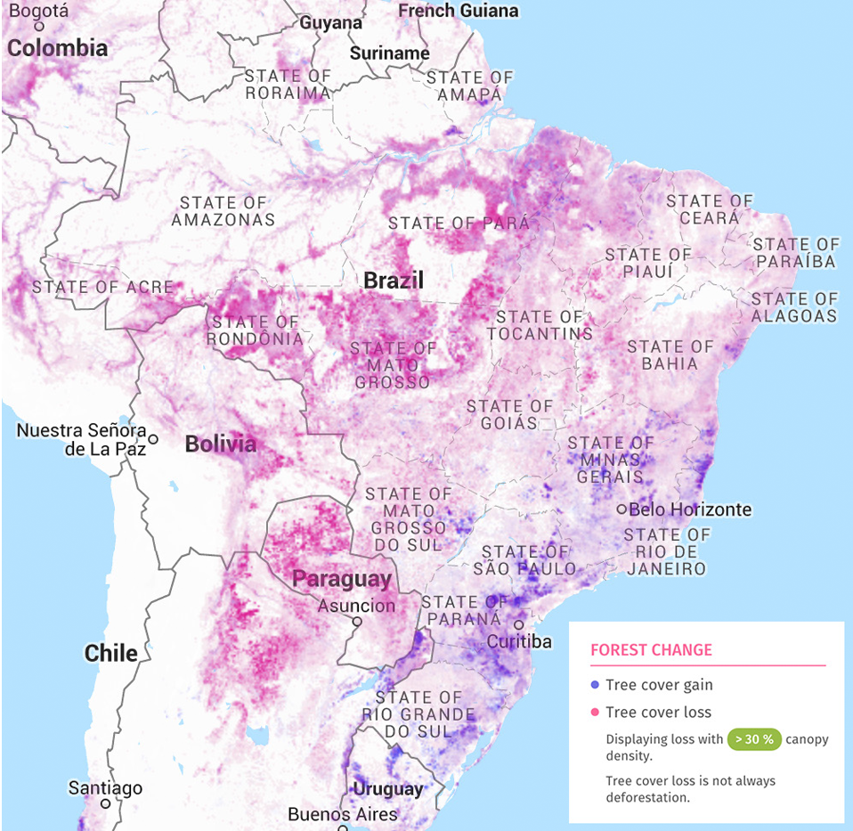
GFW’s online portal provides maps to monitor both deforestation (in pink) and reforestation (in blue) worldwide. This map shows high rates of deforestation in north-central Brazil and reforestation in the south-east of the country.
Image: From World Resources Institute, Google, and INEGI. 2015. “Global Forest Watch Map.” http://www.globalforestwatch.org/map (accessed May 1, 2015)
References
1. World Resources Institute. “Global Forest Watch.” http://www.wri.org/our-work/project/global-forest-watch (accessed May 2, 2015).
2. Interview with Lake, Sarah, and James Anderson. 2015. World Resources Institute. Interview by Cheney Wells. Phone interview. April 28, 2015.
3. Cannon, John C. 2015. “Court Rules Deforestation of Peruvian Rainforest for Chocolate Was Legal.” Mongabay, April 16, 2015. http://news.mongabay.com/2015/0416-mrn-gfrn-cannon-court-rules-united-cacao-deforestation-legal.html (accessed May 7, 2015).
4. Cheung, Loretta, Kemen Austin, Andhyta Utami, Jennifer Bangoura, and Fred Stollet. 2014. “Building National Forest and Land-Use Information Systems.” WRI Working Paper. February 2014. http://www.wri.org/sites/default/files/land-use-infomation-systems_working_paper.pdf (accessed May 2, 2015)