Eradicating Polio Using GeographicInformation Systems
DATA
Government and international health workers used digital maps to assist polio vaccination teams in rural northern Nigeria
IMPACT
Mapping helped reduce polio in the country to just 6 cases in all of 2014
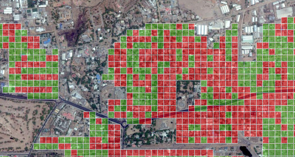
Photo: Gates Foundation, “On the Brink of Eradication,” Kano, Nigeria. Accessed from http://flic.kr/p/9bVdFN. Creative Commons BY-NC-ND license available at https://creativecommons.org/licenses/by-nc-nd/2.0. No changes were made.
In 1988, the World Health Assembly launched the Global Polio Eradication Initiative (GPEI). 1 By 2010, the initiative had limited polio to four countries, including Nigeria, where the number of known cases dropped from over 1,000 in 2005 to only 21 five years later. Internal conflict in Nigeria made complete eradication challenging, however, and the number of cases climbed back to 122 in 2012. 2 With support from the Gates Foundation, GPEI launched a plan to use geographic information systems (GIS) mapping to eradicate the disease.3
Barriers to Eradication
Several factors inhibited efforts to eradicate polio from Nigeria. The majority of polio infections occur among large nomadic populations in the northern regions of the country. Politicians and religious leaders in the area have spread misinformation about purported effects of vaccines. A surge in violent conflict in the region since 2009 further complicates logistics.
From Pilot to Scale-Up
Prior to employing coordinate-based GIS maps, vaccination teams relied solely on inaccurate hand-drawn maps, which led to some areas being excluded from the vaccination effort (see maps to the left). A 2010 pilot project tested the use of GIS technology to improve mapping, and its success pushed international donors to fund a larger scale initiative. GIS maps were created for all 2,238 wards in the eight northern states where polio was most prevalent. 4
How Digital Map Data Made a Difference
By analyzing Global Positioning System (GPS) data, the central logistics team immediately knows which areas have been missed, and can transmit this information to field vaccination teams. An online tracking system allows all stakeholders to follow vaccination coverage progress. As the image on the first page shows, neighborhoods to be vaccinated are divided into 50m2 grids superimposed on a satellite image. GPS-enabled mobile phones record the movements of vaccination teams. Green squares show visited areas and red squares missed areas. GPS tracking of teams also makes data falsification less likely, since coverage is being tracked in real time.5 The Nigeria experience suggests that similar projects could help eradicate infectious diseases in similarly remote, poorly mapped areas of other countries.
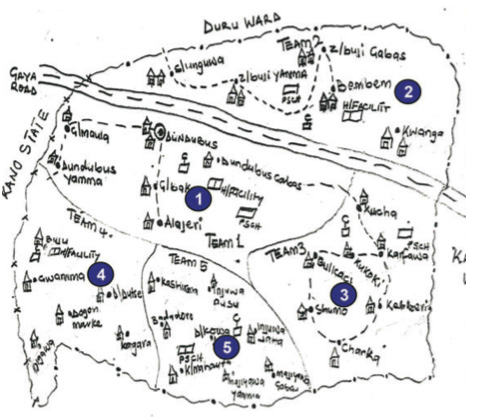
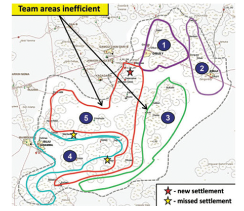
Image: From Vaccine Tracking System, National Polio Eradication Operations Centre. http://vts.eocng.org/ (accessed May 17, 2015). Used with permission.
GPS maps improved the efficiency of vaccination routes. The hand-drawn map on the left shows how teams in the past believed they were dividing areas. The GPS map of the same areas, on the right, shows that teams 3 and 5 were actually given inefficient routes, and two settlements (indicated by yellow stars) were missed entirely. Source: Barau et al. 2014
References
1. World Health Organization. 2015. “Poliomyelitis.” http://www.who.int/mediacentre/factsheets/fs114/en/ (accessed May 8, 2015)
2. Barau, Inuwa, Mahmud Zubairu, Michael N Mwanza, and Vincent Y Seaman. 2014. “Improving Polio Vaccination Coverage in Nigeria Through the Use of Geographic Information System Technology.” Journal of Infectious Diseases 210 (suppl 1): S102–10.
3. Beaubien, Jason. 2014. “Nigeria is on the Verge of Bidding Goodbye to Polio.” National Public Radio, February 12, 2014. http://www.npr.org/blogs/goatsandsoda/2015/ 02/12/385759694/nigeria-is-on-the-verge-of-bidding-goodbye-to-polio (accessed May 6, 2015)
4. Barau et. al. 2014.
5. Gammino, Victoria. 2014. “Polio Eradication, Microplanning, and GIS.” CDC. June 27, 2014. http://blogs.cdc.gov/global/2014/06/27/2986/ (accessed May 6, 2015)